Technical specification
The user can draw the parcel, field and part of field. Parcel represent the cadastral parcel which is fixed and it can't be changed from season to season. The parcel can be divided into multiple fields, as multiple parcels can represent only one field. The field represent the production units where the crop is cultivated. Only one crop can be planted per field. If user is planning multiple crops per field, it is necessary to make parts of field from the main Parcel, where each part of the field will represent a single crop. The application allows three ways of drawing the parcel / field / part of the field.
- Drawing on the Android phone or tablet screen by marking the edges of the field.
- Using a GPS module from an Android phone or tablet, by marking the border points that the software connects to single parcel. The starting point must be the final point in order to close the polygon,
- By clicking the Enter Coordinate button. After clicking on it, a window will appear, which will allow you to manually enter desired coordinates of the field.
For entering coordinates, our system uses European Terrestrial Reference System 1989, 4258 - ETRS 89
Coordinates are entered in the following format:
First point: 45.5637, 19.7464 ( longitude and latitude)
The procedure is the same for any next point the user wants to add.
For example, let’s enter second point: 45.5658,19.7460,
third point: 45.5664, 19.7515,
fourth point: 45.5644, 19,7519,
In window which appears the user enters Field name.
Plot area is calculated automatically.
New Field is saved by touching the Save icon in the upper right corner.
An example of a screen with a field drawn by manually entering coordinates:
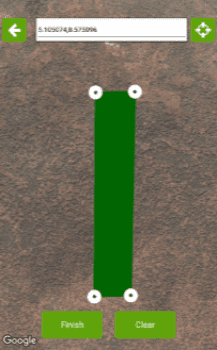 Figure 1: Drawing a field using coordinates